Maps
Blog Archive
▼
2008
(53)
►
December
(24)
▼
November
(29)
DOQQ
DEM
DLG
DRG
Isopleth
Isopach
Isohyet
Isotachs
Isobars
LIDAR
Doppler Radar
Black and White Aerial Photo
Infrared Aerial Photo
Cartographic Animation
Statistical Map
Cartograms
Flow Map
Isoline Map
Proportional Circle Map
Choropleth Map
Dot Distribution Map
Propaganda Map
Hypsometric Map
PLSS Map
Cadastral Map
Thematic Map
Topographic Map
Planimetric Map
Mental Map
About Me
Danielle
View my complete profile
Thursday, November 27, 2008
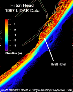
LIDAR
LIDAR images use light detection and ranging to collect topographic data. This photo was taken and used by NOAA to detect shoreline changes.
http://www.csc.noaa.gov/products/sccoasts/html/images/lhilt.gif
No comments:
Post a Comment
Newer Post
Older Post
Home
Subscribe to:
Post Comments (Atom)

No comments:
Post a Comment