Maps

Blog Archive

  • ▼  2008 (53)
    • ►  December (24)
    • ▼  November (29)
      • DOQQ
      • DEM
      • DLG
      • DRG
      • Isopleth
      • Isopach
      • Isohyet
      • Isotachs
      • Isobars
      • LIDAR
      • Doppler Radar
      • Black and White Aerial Photo
      • Infrared Aerial Photo
      • Cartographic Animation
      • Statistical Map
      • Cartograms
      • Flow Map
      • Isoline Map
      • Proportional Circle Map
      • Choropleth Map
      • Dot Distribution Map
      • Propaganda Map
      • Hypsometric Map
      • PLSS Map
      • Cadastral Map
      • Thematic Map
      • Topographic Map
      • Planimetric Map
      • Mental Map

About Me

Danielle
View my complete profile

Sunday, November 30, 2008

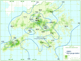
Isohyet

An Isohyet is a line on a map connecting places having equal rainfall. This map was taken off of the Hong Kong weather website.
http://images.google.com/imgres?imgurl=http://www.weather.gov.hk/informtc/prapiroon/prapiroon_rf.gif&imgrefurl=http://mattsmapcatalog.blogspot.com/2008/08/isohyets.html&usg=__O7ui_GZGohVPX7UR1Qs8KY-lnjE=&h=464&w=618&sz=110&hl=en&start=2&um=1&tbnid=YdSIw7iwfBwsuM:&tbnh=102&tbnw=136&prev=/images%3Fq%3Disohyet%2Bhong%2Bkong%26um%3D1%26hl%3Den%26rls%3DSUNA,SUNA:2006-04,SUNA:en
Posted by Danielle at 12:36 PM

No comments:

Post a Comment

Newer Post Older Post Home
Subscribe to: Post Comments (Atom)