Maps

Blog Archive

  • ▼  2008 (53)
    • ►  December (24)
    • ▼  November (29)
      • DOQQ
      • DEM
      • DLG
      • DRG
      • Isopleth
      • Isopach
      • Isohyet
      • Isotachs
      • Isobars
      • LIDAR
      • Doppler Radar
      • Black and White Aerial Photo
      • Infrared Aerial Photo
      • Cartographic Animation
      • Statistical Map
      • Cartograms
      • Flow Map
      • Isoline Map
      • Proportional Circle Map
      • Choropleth Map
      • Dot Distribution Map
      • Propaganda Map
      • Hypsometric Map
      • PLSS Map
      • Cadastral Map
      • Thematic Map
      • Topographic Map
      • Planimetric Map
      • Mental Map

About Me

Danielle
View my complete profile

Sunday, November 30, 2008

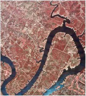
DOQQ

DOQQ or Digital Orthographic Quarter Quads are aerial photos with map qualities. This is clearly an aerial photo. It is used by the University of Texas Civil Engineering in preparation for flood insurance.
http://www.crwr.utexas.edu/gis/gishydro00/Class/trmproj/Donnelly/termproject_files/1_Red_DOQQ.jpe
Posted by Danielle at 5:15 PM

No comments:

Post a Comment

Newer Post Older Post Home
Subscribe to: Post Comments (Atom)